“RS-50M” has been added to your cart. View cart
Chartplotter KM-8C/ONWA
The KM-8C chartplotter is a multifunctional 8-inch TFT display from ONWA with a built-in echo sounder. The built-in GPS receiver displays cartographic information: position on the map, route traveled, saved waypoints. And the presence of an echo sounder allows you to determine the structure, bottom relief, and fish accumulation.
$478.00
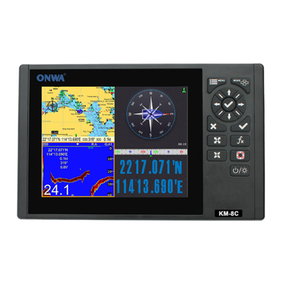
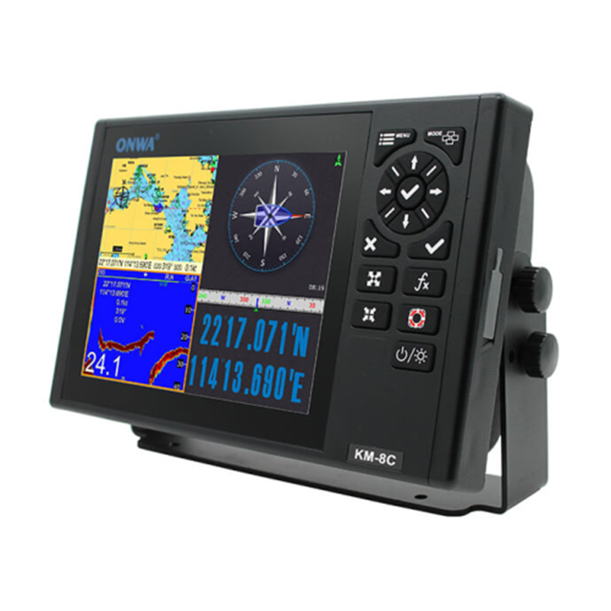
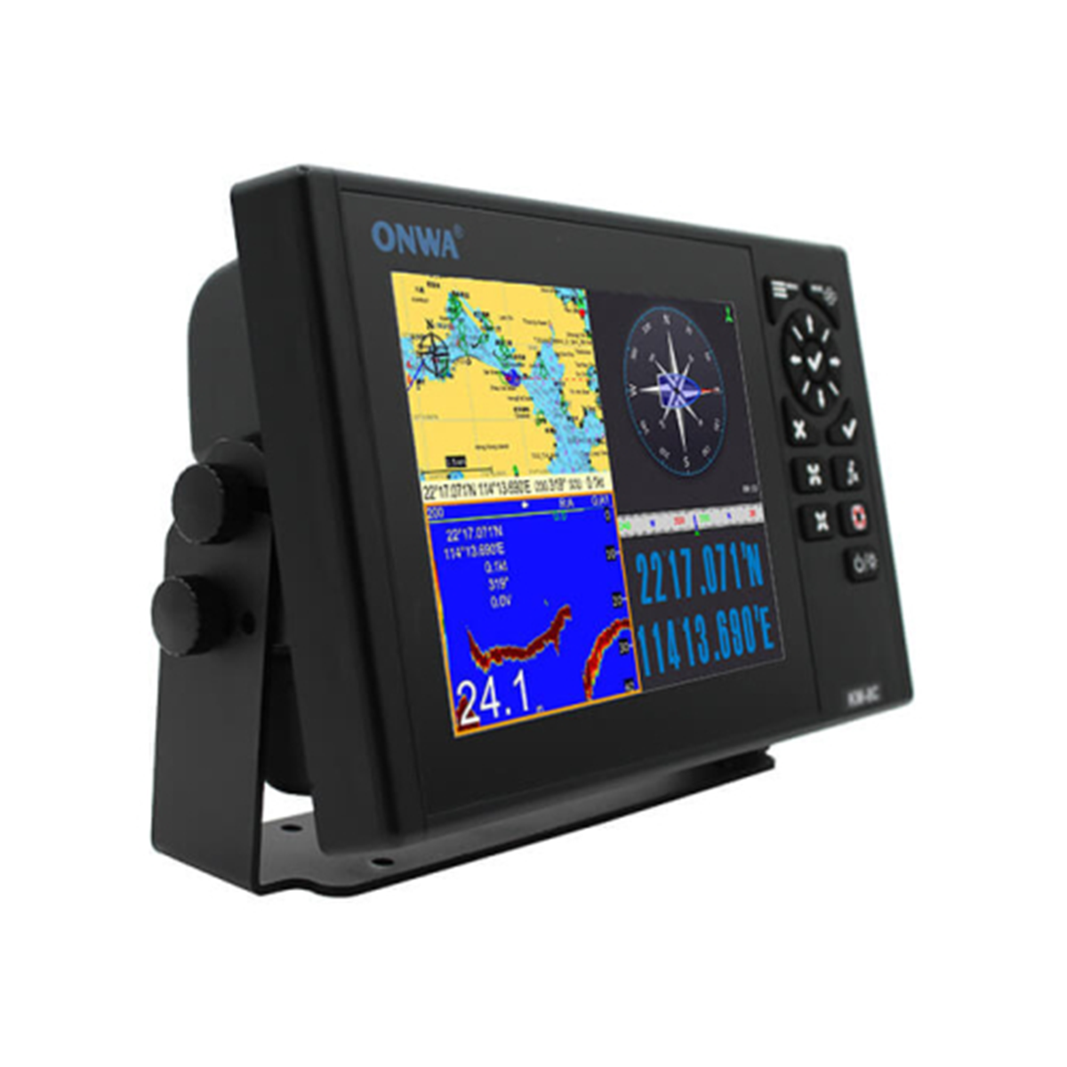
Chartplotter Onwa KM-8C
Information exchange between radio navigation devices is carried out using the NMEA 0183 / NMEA 2000 format.
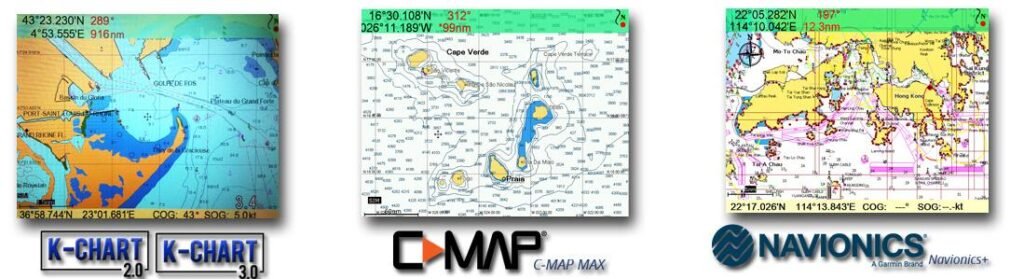
The KM-8C chartplotter supports the following charts: C-Map MAX, K-Chart, Navionix+. The device has several display modes.
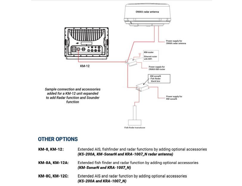
The functionality of the KM-8C GPS chartplotter can be expanded with additional accessories:
- Radar function (optional radar antenna)
- The navigation device display operates in the temperature range from -15℃ to +55℃, and the antenna unit operates in the range from -25℃ to +70℃.
- The high degree of protection of the display IPX6 allows the device to be used in difficult operating conditions.
Applications of the KM-8C ONWA chartplotter
- Navigation. The device provides data exchange between ships and coastal stations.
Reasons to buy the KM-8C navigation device:
- 8-inch TFT display
- Built-in echo sounder
- Built-in GPS
- Support for C-Map, K-Chart, Navionics+ charts
- High degree of protection IPX6
Compatible cards
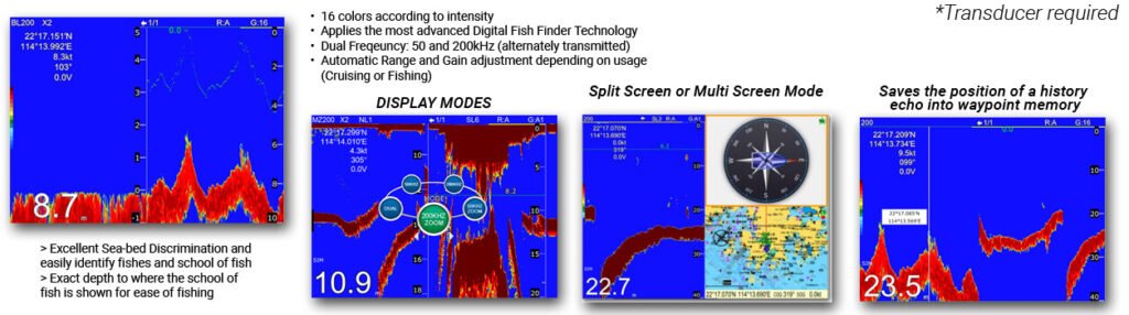
Built-in echo sounder function
Expandable function
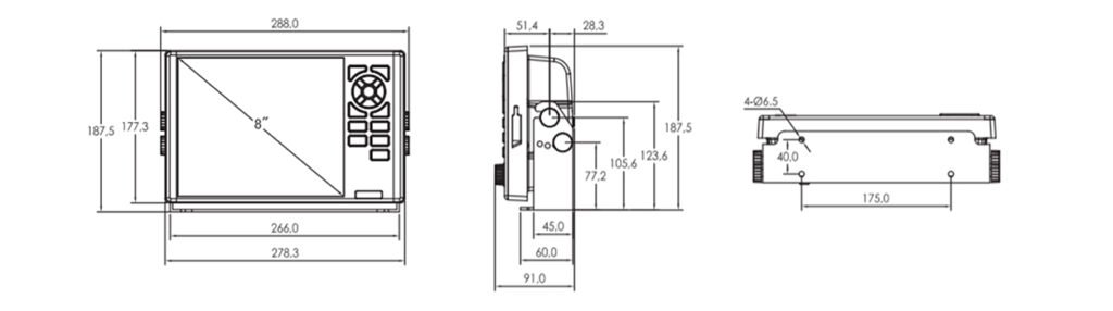
Dimensions
Plotter | |
Waypoints/Marks | 12,000 user waypoints with name, symbol, 3 system waypoints: MOB, Start, Cursor, 10 approach points |
Routes | 30 routes with waypoints, up to 170 points each, as well as MOB and track navigation modes or go to track |
Tracks | Automatic tracking log 8000 points 10 saved routes (up to 8000 points on each) Allows you to track your route in both directions |
Drawings | 1000 characters to draw; 2000 lines to draw (40 dots each); 1000 place names; 8 colors to draw |
Palette | Normal, Sunlight, Night Mode, NOAA Map Color |
Ebb and flow | Built-in tide data for around the world |
Position format | LAT/LON |
Base map | Worldwide |
External map | Compatible with K-Chart2.0, K-Chart3.0, C-MAP MAX and Navionics+ |
Storage of user data | Internal backup of user settings or external SD card |
Plotting intervals | from 5 seconds to 60 minutes or from 0.01 to 1 m |
Construction of scales | from 0.001 to 700 nm |
GPS | |
Receiver | With 50 parallel channels, continuously tracks and uses up to 50 satellites to calculate and update your location |
Data collection time | Cold start: 29 seconds Hot start: 1 second |
Refresh rate | 1 sec. or 0.1 sec. (selectable) |
Accuracy | Position: 3m (95%) without S/A |
Speed | 0.1 m/s without S/A |
SBAS | Supports |
QZSS | Supports |
Satellite system | Choice of 4 GNSS: GPS, Beidou, GLONASS and Galileo |
Dynamics | Altitude: 18,000 m Speed: 515 m/s |
System | WGS 84, user defined |
Antenna | KA-07 |
GPS interface | |
GPS data | RS232 input/output, NMEA 0183 V3.01 and V4.11 |
GPS Input Signal Frequency | Automatic scanning (4800, 9600, 19200 and 38400) |
GPS data transfer rate | Selectable between 4800, 9600, 19200 and 38400 |
Echolocation unit characteristics | |
Echo Color | 16 colors (including background color) Depending on the echo intensity. The background color can be selected from blue, light blue, white and black |
Base range | 5/10/20/40/80/150/200/300/600/1000 m (main ranges can be changed in the system menu) |
Range Shift | Up to 1000 meters (3000 feet, 600 fathoms) |
Scaling range | 2,3,4 and 6 ranges |
Bottom lock | 5/10 meters, 10/20 feet, 2/5 fathoms |
Support for NMEA0183/2000 protocol | |
ENTER, auto scan speed | GGA, GLL, GSA, GSV, RMC, HDG, HDM, HDT VTG, ZDA, MTW, VWR, VWT, MWD, VPW, VHW TLL, TTM, VDO, VDM, GNS, MTA RMA, DBT, DPT, MWV, BWC, XTE, ZDL, WPL, AAM, APB, BOD, RMB, DSC, MDA, RPM, XDR |
OUTPUT, data transfer rate: selectable 4800, 9600, 19200, 38400 | GGA, GLL, RMC, GSA, GSV, AAM, APA APB, BOD, BWC, BWR, DBT, DPT, HDT MTW, RMB, TLL, VTG, WPL, XTE, ZDA ZTG, ZDL, MWD, VPW, VWR, VWT |
Autopilot outputs | APA, APB, XTE, BOD |
Power supply | 10.5 to 30 VDC, current consumption 1.0 A at 12 V |
Physical data | |
Size | 187mm(H) X 288mm(W) X 79mm(D) |
Weight | 2.1kg |
Display | 8-inch color TFT display, 1024×768 pixels |
Water resistance | Display (front panel): IPX6 Antenna unit: IPX6 |
Temperature range | Display: -15℃ to +55℃ Antenna unit: -25℃ to +70℃ |
Ethernet port | Onwa radar, KM-sonar, KM-router, ONENET (beta version) |
Basic configuration of the KM-8C chartplotter with echo sounder
- Display unit – 1 pc.
- GPS antenna (10 m cable) – 1 pc.
- Mounting brackets
- Standard set of accessories
- Echo sounder transom sensor – 1 pc.


